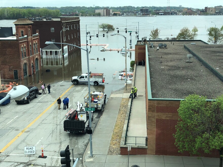
A portion of Davenport’s riverfront downtown district is still flooded after a line of temporary barriers failed Tuesday afternoon. Historic river levels and recent rains broke through portions of the barricade, swamping parts of the Mississippi River town.
The flooded Mississippi River broke through a line of sand-filled HESCO barriers Tuesday afternoon around 3:30 pm, sending what some residents described as a “waterfall” of floodwaters into the area of Pershing Street and Second Street.
In a matter of minutes, the water rushed forward, covering the road up to Third Street, submerging vehicles and cutting off access to some businesses and the apartments above them.
Amanda Kauffman was at work at Salon Static on Second Street when the river overtopped the barrier just a few doors down from her hair salon.
“Everything was just coming over the top, it was just rushing, rushing, rushing. Within a matter of, I’m going to say three to five minutes, it was all the way up to Second Street, Third Street on some,” Kauffman said. “It was chaos for a good 45 minutes to an hour.”
"Everything was just coming over the top, it was just rushing, rushing, rushing [...] it was chaos for a good 45 minutes to an hour." - Amanda Kauffman, Davenport resident
Local law enforcement escorted 30 people from their apartments, some by boat, though it’s not clear how many total residents have been displaced. No injuries have been reported at this time. Local officials estimate the worst affected areas have about 18 to 30 inches of water around the buildings.
Mayor Frank Klipsch says the community is “resilient,” and the city will work with residents and business owners to clean up, return and re-open, and to continue to “embrace the river.”
“We live with this river. It’s been the heartthrob of all of us, and we want to not only protect it but protect our citizens,” Klipsch said. “This temporary flood protection system has worked well. The last major flood that got up to this level was over…almost 26 years ago.”
The river is forecasted to crest at 22.4 feet over Wednesday night or Thursday morning, a historic height and just shy of the top two crests on record, in 1993 and 1965.
The failure of a portion of the city’s temporary flood barriers comes after more than a month of major flooding in Davenport, as measured by the National Weather Service.
Good morning from @cityofdavenport, where the Mississippi River overtopped a temporary flood barrier yesterday, sending water into the riverfront downtown business district. #ia #iawaters #iawx #Flooding2019 @IowaPublicRadio pic.twitter.com/p2HAQdVBiC
— Kate Payne (@hellokatepayne) May 1, 2019
Portions of the city’s riverfront parks, some roads and railroad lines have been underwater for weeks. Some businesses near the waterfront have watched their basements take on water as the river ebbs closer, and the water table rises up through the stormwater sewer, due to a wet winter and saturated soils. Some businesses have been pumping out their basements around the clock, sending water out even as more flows in.
Davenport Public Works Director Nicole Gleason says the sheer amount of water that has infiltrated the city’s infrastructure, above and below the street level, likely undermined the temporary flood barricades.
“The height of the river water had exceeded any other level that we had used this flood protection before,” Gleason said. “The previous night we did receive several inches of rain that contributed. And there’s also unknown conditions of the underlying infrastructure. Obviously this road, the sewer systems have all been underwater for upwards of 48 days and we’ve just never had anything like this happen before.”
This week’s crest is posing a threat to the city’s sanitary sewer system as well. Davenport’s wastewater treatment plant is located on the river, some three miles from the hardest-hit parts of downtown. Gleason says the plant is taking on more liquid than it’s designed to handle, which is stressing the system.
If utility workers determine the over-capacity flow could compromise the system, they would close off a floodgate and cut intake to the plant, Gleason says, which would mean the sewer system could potentially back up into residents’ pipes throughout the city.
“We are very close to that line and monitoring it minute by minute,” Gleason said. “If the gates close it could potentially cause sewer backups, depending on what capacity is in the rest of the system. But we don’t know exactly, specifically where that could happen.”
Gleason says the next day or so is critical for the plant, but she says the pressure on the system should lessen if river levels drop into Wednesday night and Thursday morning as forecasted.
"This road, the sewer systems have all been underwater for upwards of 48 days and we've just never had anything like this happen before." - Nicole Gleason, Davenport Public Works Director
Scott County Emergency Management Director David Donovan says it’s not clear how much damage the county has taken on, though he roughly estimates the number to be several millions of dollars. The full scale of the damage may not be assessed until the floodwaters recede, which could be several weeks, he says.
But beyond that, the National Weather Service expects the Mississippi will likely remain at flood stage through most of May, depending on rainfall.
Donovan says residents should be prepared for the possibility of continued flooding, which could reach even higher levels.
“It’s unprecedented, the duration of this flood. The ground and the soils here as well as to our north remain very saturated,” Donovan said. “Our partners at the National Weather Service who we’ve been working very closely with continue to caution us that additional heavy rain could certainly result in subsequent crests and could be higher crests.”
Scott County has activated state and local disaster declarations and is in the process of requesting a presidential disaster declaration, which would free up additional funding.
The county is working over the next few days to open a resource center where residents and business owners will be able to apply for assistance. In the meantime, a shelter is open at Lincoln School at 318 East 7th Street and help is also available from the Red Cross and the Salvation Army.
Residents can keep up to date on flooding information from the National Weather Service and the Scott County Emergency Management Department.
Those looking to help volunteer can call 563-484-3086. Those who are in need of volunteer assistance can call 563-484-3098.


