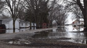
The threat of spring flooding remains in the Missouri and Mississippi River basins, including western and eastern Iowa, according to a second spring flood outlook the National Weather Service released Thursday.
Mirroring an outlook released two weeks ago, the threat of Missouri River flooding remains above normal. The river from below Sioux City to Omaha, Neb. has an increased risk of reaching flood stage. That's according to a spring flood outlook for parts of southwest Iowa and eastern Nebraska. There is also a high likelihood of getting to minor flood stage and a greater than 50 percent chance of reaching moderate flood stage below the Platte River. The soils in the Missouri River Basin are very wet. Very wet soil can't hold anymore water and could cause it to run off into streams and rivers.
David Pearson, a hydrologist for the National Weather Service in Omaha who prepared the outlook, wrote that generally weather has been dry over the last couple of weeks, though temperatures have been below-normal. This has caused the flood threat to stay the same.
“To reduce the flood threat, we need dry weather to continue,” Pearson said in an email to IPR. “The latest forecasts suggest that is the case over the next several days. There are also indications of that into the later parts of March. But we will keep monitoring to see if that is true.”
Besides very wet soil, the volume of the water moving down the Missouri River is above normal. Pearson said in his outlook that how much precipitation we get and where the rain will fall will serve as another big factor that determines how intense flooding is this spring.
In the NWS Sioux Falls coverage area, northwest Iowa tributaries including the Big and Little Sioux Rivers, are expected to rise to major flood levels.
If snow continues to melt steadily rather than rapidly, it would be better for the Missouri River and its tributaries, said Mike Gillispie, a hydrologist with the National Weather Service in Sioux Falls. He explained this by comparing it to turning a sink on and off quickly and slowly.
“If you turn it up – if you have a real rapid snowmelt – all that water comes off at once,” Gillispie said. “If you have temperatures getting up into the 40s during the day, dropping back below freezing at night, it’s like turning the faucet on just a little bit and then shutting it off.”
The National Weather Service is still expecting an elevated flood risk – especially major flooding – across the Mississippi River Basin, despite the dry weather over the last couple of weeks. Andy Ervin, a meteorologist for the National Weather Service Quad Cities, said eastern Iowa tributaries have a “near to above average” risk for flooding. Those include the Iowa River, Cedar River and others.
“When it comes to the tributary rivers, the biggest factor will be how will the spring rains go? Do we get heavy rain, do we get repeat heavy rain? That will determine the severity of our flooding if it happens on our tributary rivers,” Ervin said.
The National Weather Service plans to release a third flood outlook for this spring on March 12.


